 It started when I was looking at Google’s new Google Map Engine and the maps showing the world’s landscape that is not covered by roads.
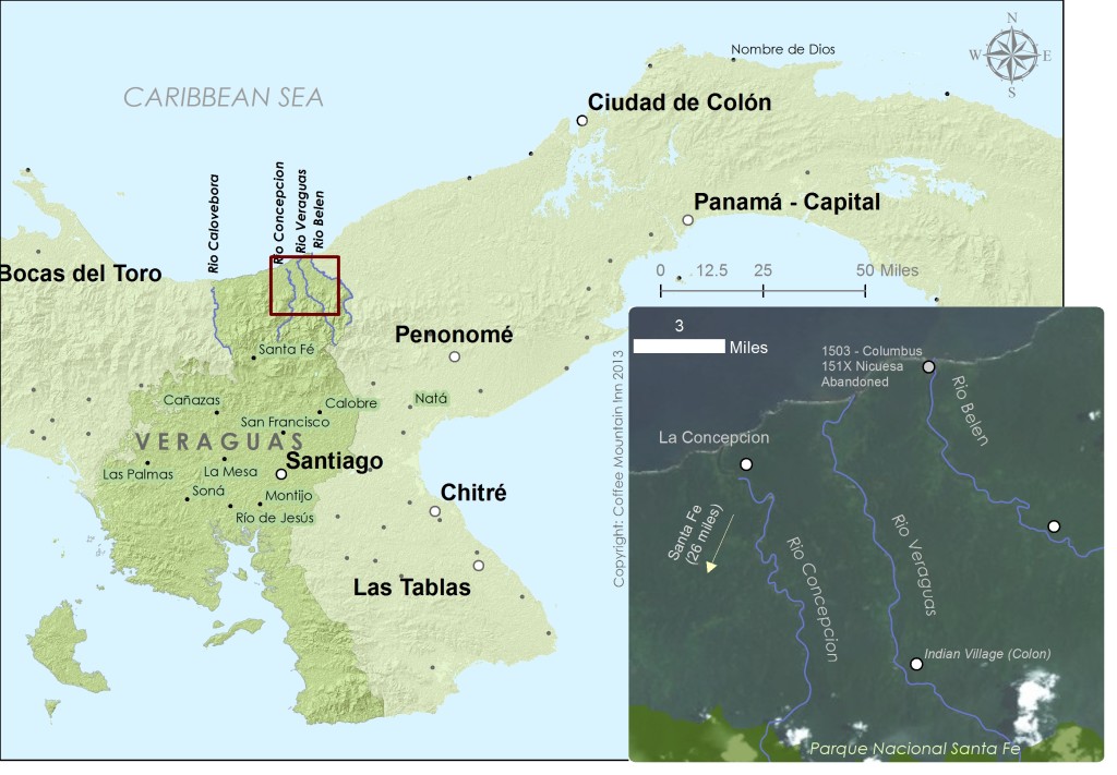
North Veraguas is such a place, but oddly enough, Rio Belen, Rio Veraguas and Rio Concepcion were home to some of the earliest settlements in the New World (failed settlements, but colonies just the same). I started doing a bit more reading and got hooked.
Christopher Columbus Starts a Settlement in Veraguas
Christopher Colombus (or Colon in Spanish), sailed down with his brothers along the Central American Coast in their fifth voyage from Spain in 1502. They stopped to trade in the indigenous villages along the coast of “Veragua” and were impressed with the apparent wealth of gold that Columbus tried to establish a base at the mouth of Rio Belen, leaving his brother in charge. Their goal- to find and discover gold. Their technique – kidnap the nearest indian chief who lived on Rio Veraguas and say you’ll let him go if he gives you a lot of gold. Do you think this technique helped win friends and influence people? Nope. Turned out that the chief’s supporters didn’t really like this idea, and attacked the barracks that Colon had established. Drove the sailors out.
Please eliminate my competition for me!
A little manipulation goes both ways. A few weeks prior, the indian chief had offered to show the explorers where he got his gold from. Sailors traveled by boat to his town on Rio Veraguas, then by foot for 16 miles through the jungle to come to an area where gold could be gathered with little effort. Great, right. Rumor is that the indian chief showed the sailors -not where he mined for gold – but where a competing cacique’s mined for gold.
It’s mine, mine, all mine…if only I can find it again
After, Colon and his brother left, he remained so strongly convinces of the promise of gold in the area, that he erased Veraguas coast and Belen from his maps, to keep the location a secret.
Which evidently was an issue…more to come!
