Swim like a duck: Charco Piedra del Pato in Santa Fe

Still water at charco pato - Santa Fe

Swimming and River Fun

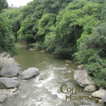
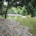
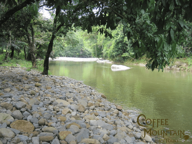
In Santa Fe, Veraguas and ready for a dip in the river or a float in a tube? Downhill (going there, definitely not going back – if you’ve seen that hill, you know what I’m talking about) from the hotel is one of the prettiest lazy swimming holes, surrounded by tall trees and a nice river.  It is a bit rocky, so I wear my flip flops in the water.
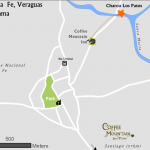
How to get there?

Go downhill from our hotel about 400m until you hit the Bulaba bridge.  Cross it, and on the other side to the right, make your way down to the river.  The swimming hole is downstream about 100m

Be careful and aware

Who would I be without cautionary words.  While the river is calm in this area much of the year, there are times that the water and velocity is high.  Use common sense – if it looks dangerous – don’t do it.

UPDATE: naming of the Charco

Since originally writing this post last week, I’ve learned of two background stories about Charco Piedra del Pato.  See which one you like the best.  The first is from Nathali who says she read the story in a book of legends of the area, the second from her mom, Villa.

1)  From Nathali: The swimming hole is located on the Bulaba River, named for an indian cacique Bulaba.  Bulaba had a beautiful daughter who fell in love with a man from a neighboring tribe. They would meet at night at this pool.  After realizing that his daughter was sneaking out at night to meet with her love interest, Bulaba was not happy and wanted to put a stop to the romance.  He went to see a warlock who turned the boyfriend into a duck (pato).  The daughter went at night to wait for her boyfriend, sitting on the big rock in the middle of the second photo – she sat and sat, he never came.  Thus, the area was named the Pool of Duck Rock (Charco Piedra del Pato)

2) From Villa: There used to be a lady named Sra Inez who lived on the river.  She had many ducks and the ducks used to perch themselves on the rock. Thus, the area was named the Pool of Duck Rock (Charco Piedro del Pato).


I am number one! You are number 2!

Narices River, Santa Fe Nationa Park, Veraguas, Panama
Narices River, Santa Fe National Park, Veraguas, Panama

Rio Narices, Santa Fe National Park – Stories from Cele

Rio Narices is an amazingly clear river that flows down the Pacific side of Santa Fe National Park, joining the Santa Maria River about 2 miles to the north east of Santa Fe, one of the 10 largest rivers in Panama. There is clear, still water, some neat geologic formations, forested slopes, and about 3 miles in, a little palm rancho that ANAM built.

Cele’s hiking recommendations

We wore rubber knee high boots when hiking up the river.  There were some places where we had to cross from bank to bank to continue walking, and in places the water was pretty deep.  Bring food if you want to hike up, I didn’t and was hitting on empty when we got back. The going is slow.  We walked in maybe 3 miles to the ANAM rancho.  The term rancho makes it sound bigger than it is.

Philosophical question for this hike

Rancho Narices, Santa Fe National Park
Rancho (ANAM), Santa Fe National Park

Indigenous groups have lived in Veraguas for centuries if not millenium, living in small communities.  Santa Fe National Park was finally formed in 2001, and encompasses some  villages.  Up Rio Narices, and over the cordillera central, and going down the river on the other side of the continental divide, there are three communities: numero uno (number one), numero 2 (number 2) and Guazaro, accessible by foot, a total of 12 hours hiking one way.

So, think about it.  You’re living in an isolated community, not much entertainment, except the communities down the way.  I’m sure they get together for festivals, make life interesting.  Do you think the villagers debate which town is number one and which is number 2?  Ah, we are number one because we are closer to the ocean, your town is number two.  No no no, we are number one since we’re closer to Santa Fe, you live in number 2.  How about your psyche.  Would you grow up feeling inferior if you grew up in number 2?

Cerro Tute – can I be a rebel too?

Cerro Tute overlooking Santa Fe Valley in Veraguas, Panama
Cele at Cerro Tute

 Santa Fe, Panama – Cerro Tute Exploring

I have watched youtube videos of places to go and things to do, and have been impressed by those of hikers going up Cerro Tute.  Young hikers  out of breath, hiking for hours to see the panaromic views from the Cerro which hovers protectingly at 1061m over Santa Fe, Veraguas with its sister hill Cerro Mariposa, known for its birding.  Unlike Cerro Mariposa, Cerro Tute is   deforested and known for —well rebels like you and me.

Not quite.

But it is known for rebel hideouts, first indian caciques lanced some of their resistance against the Spaniards from the cerro, and more recently in the 1950s a group of Fidel Castro inspired Panamanian university student rebels hid from the pursuing governmental forces in Cerro Tute.  The government eventually lured them down with rumors of gun shipments, or so I hear.  Many were killed, others escaped.

Today the Cerro hugs the edge of Santa Fe National Park.  Country folk live in its hill sides. And, it has great views.

How we got there

Cele and I decided to check it out, but in our 4X4 rather than walking, to see how far we could get.  They’ve been working on the road, and we saw our tax dollars at work with the new tourism authority signs for the cerro.  So we followed them.  We took the red route on the map below – starting point – the inn of course!  We followed the signs south of town to the Cerro.   20 minute drive-up hill with some great views of town.  We didn’t go all the way to the top I don’t even think we  used the 4×4.

Recommendation?

How was it, well it was nice. (6.5/10).  The problem with Santa Fe is that there are so many places with sweeping views.  Was it fun, yeah.  Were there great views,  yup- looking out towards Santiago  But it wasn’t forested, no fantastic rivers, and the drive wasn’t as interesting say as going to Alto Gonzales to the north, or the road to Guabal.  There is an alternate route (blue), which is supposedly rougher.

Recommendation: Go up with a car for a picnic lunch or to watch the sun rise/sun set.

Cerro Tute Routes - by Car
Exploring the Cerro